How does GPS tracking work?
It’s almost unimaginable today that someone in North America wouldn’t have experience with a global positioning system (GPS). Most of us have GPS devices on our phones, and many of us have GPS trackers in our cars. Commercial fleets can also use GPS tracking to improve productivity and track assets.
Yet how many of us actually understand how GPS works?
This section answers that question and shares GPS tracking systems’ many applications and advantages.
What is GPS tracking?
In simple terms, GPS is a technology that tracks the location of an object. While GPS tracking is a relatively new technology, the process it uses to track objects has been around for over 100 years.
Triangulation is at the heart of what GPS does. Before satellites, triangulation measured distances. With the invention of radios, we used the same technique of measuring the strength of a signal and direction to triangulate where a signal originated.
Satellite navigation relies on radio signals transmitted from medium-earth orbit. GPS satellites emit signals used by GPS tracking devices to determine location and time accurately.
It may sound complicated, and a little rocket science is involved, but what GPS tracking means for your company is that you can know where a vehicle is, how fast it’s traveling, and the estimated time of arrival.
What is the history of GPS?
The military initially developed the GPS system in the 1960s. The United States Navy began using satellite navigation to track submarines carrying nuclear missiles. By sending and observing signals to six satellites in space orbiting the poles, the Navy could find submarine locations within minutes.
The Department of Defense (DoD) got on board in the 1970s and launched the first Navigation System with Timing and Ranging (NAVSTAR) in 1978. By 1993, NAVSTAR was a fully operational 24-satellite system for multi-use navigation.
Today, there are 31 GPS satellites operated by the U.S. as part of the Global Navigation Satellite Systems, which serve the international community.
How GPS tracking works
A GPS tracking device, fitted with a receiver, is attached to the object you want to monitor. The device is also built to record the time and location (using latitude and longitude) in relation to the GPS satellites.
Finding one object’s location takes multiple satellites. While hurtling hundreds of miles per hour in space, the satellites bounce a signal back, and the time it takes for it to return allows the transmitter to calculate the distance from each satellite. The receiver uses the difference between the signal broadcast and reception time to compute distance.
The more satellites that send back a signal, the more data there is to make a precise measurement. Accounting for delay and signal speed changes caused by the fact that it’s traveling through the earth’s atmosphere, the GPS uses information about the device’s range from three satellites and the satellite’s location when the signal was sent to plot a three-dimensional position.
Then, at regular intervals, the receiver relays that location data to the GPS tracking software. Data relay may be done in near-real-time (if the device has a data transmitter) or can be downloaded manually from the device. The GPS tracking software takes that recorded data and translates the logged information into a location on a map. The Motive Vehicle Gateway captures data every minute and reports it to the user’s dashboard while cable powered.
What are the uses of GPS?
Designed and maintained by the U.S. government, GPS tracking is today operated by the United States Air Force to meet national defense and homeland security needs. Still, it has many commercial applications.
1. Vehicle tracking
Vehicle tracking can apply to passenger or commercial vehicles. For example, most new car models today come factory-fitted with GPS to enable private car owners to use satellite navigation.
GPS enablement has increased driver satisfaction with their vehicles while also helping to reduce fuel expenses as individuals can take more efficient routes to their destinations.
2. Fleet tracking
In addition to tracking a single vehicle, fleet tracking uses GPS to monitor and dispatch many vehicles, assets, and trailers. The applications include:
- Taxi services
- Commercial fleets
- Freight trucks
- Waste management
- Public transportation
- Emergency vehicles
- Roadside assistance
- Trailer tracking
- School busses
3. Heavy machinery
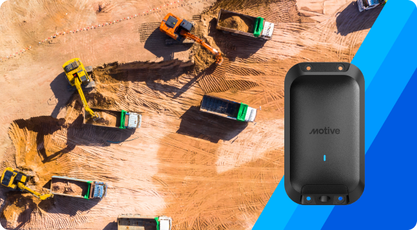
Mining and construction businesses, for instance, use GPS to make it easy for drivers to follow pre-programmed site plans and achieve close tolerance for position, gradient, and level. With in-cabin vehicle guidance and control systems, it’s also easier to avoid delays that can slow a project and cause unforeseen expenses.
GPS tracking also provides an overall map view of all the moving parts on a mining or construction site, making it easier for site managers to monitor fuel use, inventory availability, and employee productivity. Further, managers have the data they need to manage payroll, validate invoices, and produce root cause analysis if problems arise. Preventative fleet maintenance is also simplified as the technology makes tracking wear-and-tear on assets easier and anticipates when frequently used equipment needs some TLC.
4. Agricultural use
Farmers now put GPS receivers on tractors and other farming equipment to better track assets through the planting, weeding, and harvesting seasons. GPS tracking enables precision farming, field mapping, soil sampling, crop scouting, and yield mapping. GPS-based tractor guidance also helps farmers work in more difficult conditions (rain, dust, fog, and darkness), while the navigation tools enable maximum ground coverage in the shortest possible time.
With more precise applications of pesticides, herbicides, and fertilizers, farmers can also reduce expenses and see a higher crop yield while being more environmentally friendly.
5. Route planning
GPS is all about accurate and timely information, which is just what you need to plan the best route. GPS tracking systems provide real-time awareness of asset positioning and help you determine how to get from one location to another and determine the expected timing.
GPS planning makes it easier to find the best approach to a multi-stop route. Plus, the driver is aided by turn-by-turn directions that can take into consideration changes along the way from weather, traffic, or other constraints.
6. Vehicle or asset recovery
Many GPS tracking systems today allow you to find a vehicle or asset if it is stolen. Even when the stolen vehicle or asset is in motion, you can track the whereabouts to facilitate recovery.
Many GPS tracking software also allows you to set up a geofence perimeter to help prevent theft. Operators can be alerted if an asset leaves a pre-established perimeter.
How accurate is GPS?
That depends. The satellites are equipped with highly accurate atomic clocks. The U.S. government is committed to broadcasting the GPS signal in space for an accuracy range of less than or equal to 2 meters (6.6 feet), with 95% probability. Yet, the signal does depend on other factors, including satellite geometry, signal blockage, atmospheric conditions, and receiver design features/quality.
GPS-enabled smartphones, for example, are typically accurate within a 4.9 meter (16 feet) radius under an open sky, but GPS accuracy suffers near buildings, bridges, and trees. Trying to receive the signal indoors or underground can also degrade GPS accuracy.
And, in case you’re wondering, the U.S. government lets civilian and commercial users have the same accuracy in GPS signaling as the military uses. That wasn’t always the case, but in May 2000, the Clinton administration directed the government to do away with Selective Availability.
Do you need GPS tracking?
Any organization that operates commercial vehicles may benefit from GPS tracking. Taking the satellite signal for navigation and coupling it with software that integrates real-time insights into location, speed, and other data suits several scenarios. When considering a top-rated GPS tracking system ask yourself if you want to:
- Protect valuable assets in the case of theft
- Reduce fuel and maintenance costs
- Improve route efficiency
- Provide driver training opportunities
- Reduce insurance costs
- Improve customer satisfaction
- Find operational efficiencies
What are the benefits of GPS tracking?
A GPS is a must-have for companies of any size with vehicles on the road.
Advanced GPS tracking systems can collect location points every 30 seconds or so and are also based on changes in speed and bearing. This offers many important benefits.
1. Gain GPS location and alerts
A GPS is most useful if it automatically sends an alert when certain conditions are met, such as when a vehicle leaves or enters a boundary. Plus, with a high-end GPS, drivers can automatically transmit location information without having to make a phone call. GPS lets you track your fleet accurately, while improving driver satisfaction and increasing overall efficiency.
2. Efficient route planning
The shortest route between two points isn’t always the fastest. Using the cumulative history of travel routes, a GPS tracker can help calculate the fastest route based on the time of day and traffic congestion or road construction.
3. Reduce detention times
By identifying which pick-up and drop-off queues take longer than others, you can reduce detention time. You can also identify facilities that detain drivers more frequently or for the longest periods, and plan arrival times more strategically. Decreasing detention can also increase safety.
4. Tighten your delivery window
Food or other perishable deliveries require speedy, on-time delivery. With real-time GPS asset tracking, you’ll be able to provide a tighter delivery window for your customers. You can also notify clients when the unexpected collision has your delivery locked up in traffic or if any other last minute circumstances occur that are going to affect the delivery window. .
5. Improve customer service
Clients love a heads-up when expecting a delivery. The best GPS software allows you to notify them quickly and easily. With real-time visibility, customers have the most accurate ETAs so they can prep their worksite, warehouse, or receiving dock for your vehicle’s arrival.
6. Enjoy data insights
Combined with the right fleet management software, GPS data insights can help you make better fleet management decisions, including identifying the causes of increased fuel consumption. Does one vehicle in the fleet refuel more often than the others just like it? It might be due for maintenance. Is one driver more prone to jackrabbit starts or harsh braking (or taking personal errands or side jobs)? You can address these potentially problematic behaviors with more training or coaching.
7. Integrate with your ELD
If your drivers are part of the electronic logging device (ELD) mandate, a good GPS system will integrate with the ELD and help the driver stay compliant.
8. Support driver safety
By integrating the latest tools for implementing and monitoring driving behavior, you can improve driver safety. The top GPS tracking solutions analyze, contextualize, and prioritize events to save time for safety departments, help you benchmark performance, and track impact of driver coaching.
9. Geofencing
Setting up a geofence perimeter on the GPS tracking tool helps you know when your vehicles enter or leave a predetermined area. This can reduce administrative burden, increase efficiency, simplify time and payroll management, improve compliance and fleet safety, and boost customer satisfaction.
Geofencing also works as an excellent anti-theft deterrent and increases fleet security with alerts for when vehicles go beyond approved routes and virtual boundaries.
10. Smarter maintenance scheduling
Integrating GPS telematics data into a fleet maintenance platform allows you to make data-driven maintenance decisions. Instead of relying on time-based or mileage-based maintenance schedules, fleet managers can use the tracking software’s odometer readings to prompt service reminders and alerts to ensure you stay on top of each asset’s preventative maintenance.
Track your fleet accurately with Motive
GPS is a pretty amazing tool. This system increases your ability to keep your assets safe, and can also give you insight into driver behavior, ushering in training opportunities that can help you develop a strong, long-term employee.
Your business doesn’t have to be a large fleet to benefit from a high-quality GPS. Even one commercial vehicle in your fleet is important enough to protect with a GPS tracking system.
A GPS fleet tracking system is so much more than a map. With it, you can lower costs while raising your level of customer service. GPS tracking can help protect your drivers and cargo too.
Learn more about how GPS tracking works, or get a tour today to experience it all first-hand.


